- Drill Hole K16-07 assayed 252.8 g/t (8.13 oz/t) silver over 25 ft. (7.62 m) with intervals within 105 ft. (32 m) mineralized intersection averaging 79.7 g/t (2.56 o/t)
VANCOUVER, Canada – – Viscount Mining Corp. (TSX-V: VML) (OTCQB: VLMGF) (“Viscount” or “the Company”), is pleased to report drill results for all holes twinned in 2016 on the Silver Cliff property in the Hardscrabble Silver District of Custer County, Colorado (the “Property”). The program which commenced in mid-November met its primary objective of confirming the general validity of historical drill intersections of silver mineralization on one of the Silver Cliff deposits known as the Kate Silver Resource (the “KSR”).
The table below displays summary data for Viscount’s 2016 “K” series of 2.5-inch diameter holes (HQ core) along with available data for the historic holes which were twinned, including data from previously unreported Viscount holes K16-07 and K16-09. Because of the presence of strong alteration and locally visible sulphides, an additional 35 feet (122’-157’) from K16-07 and 20 feet (173’-193’) from K16-08 was sampled and sent to ALS Canada Ltd., at their laboratories in Reno, Nevada, and Vancouver, BC., by the Qualified Person (QP) during a site inspection visit from 21 to 25 March 2017.
| K16-07, K16-09 And Other 2016 DDH Results Compared With Holes Twinned | ||||||||
| Hole # | From (ft.) | To (ft.) | Dip (°) | Length (ft.) | oz/t | g/t | Easting (m) | Northing (m) |
| 73-2-CC | 54 | 98 | -60 | 44 | 67.70 | 2105.7 | 460455 | 4221740 |
| 88-1 | 65 | 95 | -60 | 30 | 16.30 | 507.0 | ||
| K16-01 | 55 | 105 | -60 | 50 | 26.92 | 837.4 | 460455 | 4221739 |
| including | 60 | 92 | 32 | 40.87 | 1271.1 | |||
| including | 60 | 80 | 20 | 57.18 | 1778.5 | |||
| 89-27 | 80 | 140 | -90 | 60 | 7.00 | 217.7 | 460605 | 4221831 |
| K16-03 | 57 | 112 | -90 | 55 | 4.55 | 141.5 | 460604 | 4221829 |
| including | 82 | 112 | 30 | 7.49 | 233.0 | |||
| 89-26 | 50 | 120 | -90 | 70 | 5.90 | 183.5 | 460575 | 4221830 |
| K16-04 | 51 | 121 | -90 | 70 | 5.74 | 178.5 | 460578 | 4221827 |
| including | 61 | 121 | 60 | 6.54 | 203.4 | |||
| including | 76 | 121 | 45 | 8.06 | 250.7 | |||
| 89-53 | 70 | 115 | -60 | 45 | 8.30 | 258.2 | 460420 | 4221650 |
| K16-05 | 65 | 110 | -60 | 45 | 12.57 | 390.9 | 460420 | 4221654 |
| 88-2 | 90 | 120 | -60 | 30 | 7.90 | 245.7 | 460483 | 4221830 |
| K16-06 | 65 | 130 | -60 | 65 | 1.05 | 32.8 | 460484 | 4221744 |
| including | 100 | 120 | 20 | 1.72 | 53.6 | |||
| 88-59 | 75 | 115 | -60 | 40 | 4.20 | 130.6 | 460451 | 4221650 |
| K16-07 | 47 | 152 | -60 | 105 | 2.56 | 79.7 | 460452 | 4221650 |
| including | 72 | 137 | 65 | 3.94 | 122.6 | |||
| including | 77 | 137 | 60 | 4.21 | 131.1 | |||
| including | 92 | 117 | 25 | 8.13 | 252.8 | |||
| 88-36 | 115 | 170 | -60 | 55 | 4.32 | 134.4 | 460513 | 4221711 |
| K16-08 | 105 | 173 | -60 | 68 | 7.35 | 228.6 | 460512 | 4221710 |
| including | 115 | 173 | 58 | 8.55 | 265.9 | |||
| 88-40 | 110 | 135 | -60 | 25 | 2.99 | 93.0 | 460543 | 4221801 |
| K16-09 | 85 | 135 | -60 | 50 | 4.39 | 136.5 | 460542 | 4221799 |
| including | 110 | 135 | 25 | 7.11 | 221.0 | |||
The silver-bearing strata are attested by the QP to be altered tuffaceous and fragmental rhyolites as described in USGS reports cited below rather than a silicified stromatolite or limestone reef as was reported in the Company’s December 21, 2016 and January 19, 2017 news release quotes. The altered, fragmental and near-horizontal nature can be seen in the two accompanying photos of core from vertical hole K16-03. The marked 97 to 102-foot interval assayed 258.1 g/t (8.3 o/t) Ag, from 102 to 107 feet assayed 693.6 g/t (22.3 o/t) Ag, and from 107 to 112 feet assayed 80.9 g/t (2.6 o/t) Ag. A 55-foot interval of K16-03 core from 57 to 112 feet averaged 141.5 g/t (4.55 o/t) Ag. The true widths of the drill hole intersections cannot be determined from the information available.
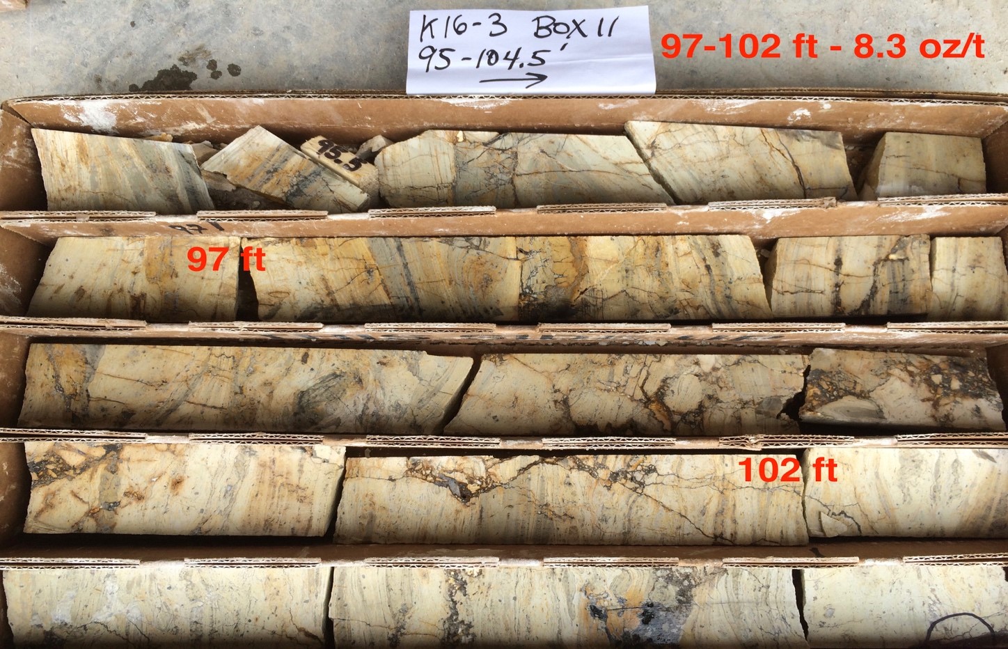
K16-3 Box 11
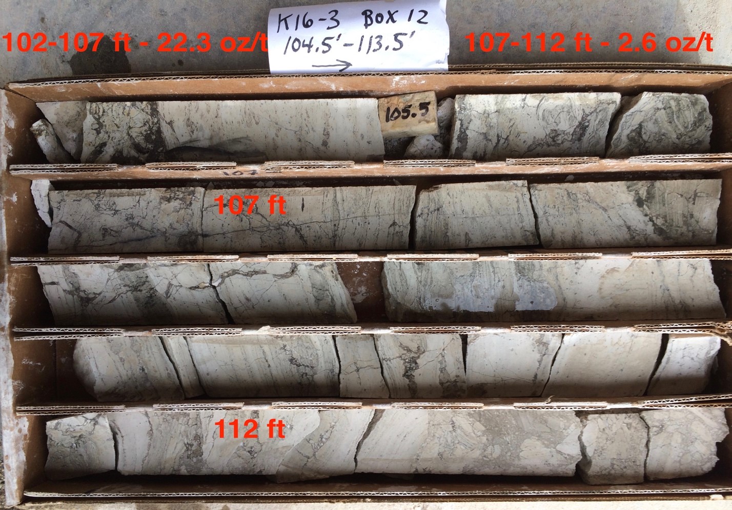
K16-3 Box 12
Future drilling will test the potential for multiple silver-bearing tuffaceous layers because Whitman Cross (USGS, 1896) reported that the shaft of the former Geyser Mine approximately 1 mile southeast of the former Kate Mine provided a “demonstration that stratified rhyolitic tuff and breccia extend to the 2,100-foot level (depth).” In the Geyser shaft, S. F. Emmons (USGS, 1896) stated that “No defined ore-body was found until the 1,850-ft. level was reached. Thin films or stains of metallic sulphides, said to assay high in silver, occurred occasionally in the shaft and in some of the drifts; lining delicate cracks in the tuff.” “The main ore-vein was first found in the 1,850-ft. level, about 300 ft. northwest of the shaft, as a narrow seam.” Emmons reported assays for two carload lots as 1.05% silver and the other 1.27% (300.28 oz/ton). The shaft bottomed in Precambrian granite and gneiss. Please note, under National Instrument 43-101 Standard of Disclosure for Mineral Projects, historical references to “ore” do not satisfy current definitions and require that the mineralized zone referred to as “ore” to be supported by a feasibility study of mineral reserves” or similar.
The first Phase of twin drilling of eight of the historical holes drilled on the Kate deposit resulted in core assay results that strongly suggest it is imperative that Viscount plan a second Phase of drilling in conjunction with a mining engineering company who will chose the number and identify the next set of historical drill holes that they will require to be twinned in order to make a silver resource/reserve estimate according to CIM standards. The new set of twin drill holes will not only help in verifying the historical Prefeasibility Study but will also test possible deeper highly altered rhyolite tuff units for the same grade and type of silver mineralization found in the shallow unit. Viscount is storing all of the drill core, coarse reject and pulp material at the Silver Cliff, Reno (ALS) and Vancouver (ALS) facilities so that they will be available for future metallurgical tests if required. Viscount is very optimistic that the next Phase of drilling will provide the basis for allow the engineering company to prepare a NI43-101 technical report.
About the Silver Cliff Property
The Silver Cliff property lies within the historic Hardscrabble Silver District in Colorado. The Property consists of 96 lode claims where high grade silver, gold and base metal production came from numerous mines during the period 1878 to the early 1900s. It is located 44 miles WSW of Pueblo, Colorado, and has year-around access by paved road. The property underwent substantial exploration between 1967 and 1984. The major explorers were Freeport, Hecla, Homestake, Moly Corp, Coca Mines and Tenneco Minerals.
The property is interpreted to encompass a portion of a large caldera and highly altered sequence of Tertiary rhyolitic flows and fragmental units which offers potential to host deposits with both precious and base metals. This has been demonstrated in the mineralization historically extracted from the numerous underground and surface mining operations.
Drilling in the 1980s by Tenneco resulted in a historical pre-feasibility study which formed the company’s decision to put the property into production. Plans were halted due to the restructuring of Tenneco after it was sold.
Quality Assurance/Quality Control (“QA/QC”) Measures, Chain of Custody
The Company has implemented a QA/QC program using best industry practices at the Silver Cliff Property. Drill core samples are sawn in half lengthwise and one half transported in securely-sealed bags to the ALS laboratory in Reno, Nevada, for analysis. Prior to transport, individual samples are labeled, placed in plastic sample bags and sealed. Groups of samples are then placed into durable rice bags that are then shipped. The sample pulps and rejects will be retrieved from ALS. All samples were analyzed for Ag and 50 other elements by ALS method “Ultra Trace Aqua Regia ICP-MS” with code ME-MS41. In the case of Ag determined by this method to be in excess of 100 ppm, a further analysis for Ag was done utilizing method “Ore Grade Aqua Regia ICP-AES” with ALS code Ag-OG46. For the three 5-ft interval samples from K16-01 containing more than 1,500 ppm Ag, the ALS method “Ag 30g FA – GRAV finish WST-SIM” with code Ag- GRA21 was utilized.
Qualified Persons
The scientific and technical information contained in this news release has been reviewed by Dallas W. Davis, P. Eng., FEC., an independent consulting geologist who is a “Qualified Person” as such term is defined under National Instrument 43-101 – Standards of Disclosure for Mineral Projects (“NI 43- 101”).
About Viscount Mining (TSX VENTURE: VML) (OTCQB: VLMGF)
Viscount Mining is a project generator and an exploration company with a portfolio of silver and gold properties in the Western United States, including Cherry Creek in Nevada and Silver Cliff in Colorado.
The Cherry Creek Property is focused on exploration in the immediate vicinity of an area commonly known as the Cherry Creek Mining District, located approximately 30 miles north of the town of Ely, in White Pine County, Nevada. Cherry Creek consists of over 400 unpatented and patented claims as well as mill rights, and is comprised of more than 9,000 acres. Cherry Creek includes more than 20 past producing mines including Blue Bird, Chance Mine, Filmore, Last Chance, Exchequer/ New Century Mine, Ticup and Motherlode mines.
The Silver Cliff property in Colorado lies within the historic Hardscrabble Silver District in the Wet Mountain Valley in south-central Colorado in Custer County. The property consists of 96 lode claims where high grade silver, gold and base metal production came from numerous mines during the period 1878 to the late 1896. Subsequently, there was little activity until the late 1960s to early 1990s when the property underwent periods of exploration and evaluation, including at least one prefeasibility study. The major explorers were Freeport, Hecla, Homestake, Moly Corp, Coca Mines and Tenneco Minerals. In January 2017, Viscount Mining reported additional high grade silver intersections from the drill program completed in December 2016.
For additional information regarding the above noted property and other corporate information, please visit the Company’s website at www.viscountmining.com
ON BEHALF OF THE BOARD OF DIRECTORS
“Jim MacKenzie”
President, CEO and Director
For further information, please contact:
Viscount Investor Relations
Phone: 1 844 863 3622
Email: info@viscountmining.com
Neither TSX Venture Exchange nor its Regulation Services Provider (as that term is defined in the policies of the TSX Venture Exchange) accepts responsibility for the adequacy or accuracy of this release.
Forward-Looking Statements
This news release contains certain statements that may be deemed “forward-looking” statements. Forward looking statements are statements that are not historical facts and are generally, but not always, identified by the words “expects”, “plans”, “anticipates”, “believes”, “intends”, “estimates”, “projects”, “potential” and similar expressions, or that events or conditions “will”, “would”, “may”, “could” or “should” occur. Although Viscount Mining Corp. believes the expectations expressed in such forward-looking statements are based on reasonable assumptions, such statements are not guarantees of future performance and actual results may differ materially from those in forward-looking statements. Forward-looking statements are based on the beliefs, estimates and opinions of Viscount Mining Corp. management on the date the statements are made. Except as required by law, Viscount Mining Corp. undertakes no obligation to update these forward-looking statements in the event that management’s beliefs, estimates or opinions, or other factors, should change.
Stay In Touch