VANCOUVER, Canada –- Viscount Mining Corp. (TSX-V: VML) (OTCQB: VLMGF) (“Viscount” or “the Company”), is pleased to provide an update on the recently completed Phase 4 soil sampling program (1,250 samples taken) as well as geologic mapping and rock chip sampling programs in the Flint Canyon area of its Cherry Creek Property (the “Property”), which is currently being explored by Summit Mining Exploration II Inc.(“Summit”), a wholly-owned US subsidiary of Sumitomo Corporation.
The soil sampling combined with previously announced anomalous rock sample results (October 29, 2015) has yielded gold (Au) and pathfinder element anomalies for Mercury (Hg), Arsenic (As), Antinomy (Sb) and Thallium (Tl) similar in size and tenor to soil and rock geochemical sampling results at other mines and advanced properties in Nevada. These include Kinross Gold’s Bald Mountain mine; Newmont Mining’s Long Canyon project, Agnico-Eagle’s West Pequop project and Pilot Gold’s Kinsley Mountain project.
Phase 4 Soil Sampling Program
The Phase 4 soil geochemical survey was concluded and results for gold are included in the May – June activity report issued by Summit for Flint Canyon on the Cherry Creek property. They state that “1250 soil samples have been collected”. This includes some samples collected outside the area shown on the accompanying Flint Canyon soil and rock sample maps provided by Summit. Analysis has been by a 51‐element + gold ICP procedure (ME‐MS41 & Au‐TL43) at ALS Labs Limited, of Elko, Nevada. The sample grid spacing is 75m by 75m and tight GPS control.
The Pogonip Limestone anomaly area includes two anomalies located in close proximity to each other. The anomalies measure 500 meters NW by 300 meters NE and 250 meters NW by 125 meters NE, respectively. The highest gold in soil value for these combined anomalies is 0.345 g/t Au (0.012 oz/t).
The Dunderberg Shale anomaly measures approximately 1,200 meters by 300 meters. The highest gold value in this anomaly is 0.106 g/t Au (0.003 oz/t). The anomaly widens or bends to the east on its northern end and it appears to be controlled by the west-southwest trending Black Metal Fault in this area.
The highest gold value on the soil grid was 0.534 g/t Au (0.018 oz/t). It is located on the east side of the survey area. The two northerly trending anomalous areas located in the center and west side of the grid contains most of the anomalous gold and pathfinder element values in the Flint Canyon area. The anomalous values are open to the south and west of the western most area where soils samples were collected.
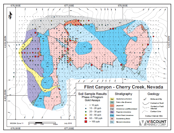
The soil gold assay map with ranges of gold values in soil shows a strong relationship between the areas with jasperoid outcrops and a surprisingly broad and strong gold anomaly on the extreme west side of the Flint Canyon area in the Pogonip Limestone. The soil gold anomaly occurs to the west of some jasperoid outcrops that are found at the contact between the Pogonip and Notch Peak formations, a common relationship found at major gold deposits in Nevada. From the distribution of anomalous gold results, there are at least two major target areas that need to be tested by several drill holes.
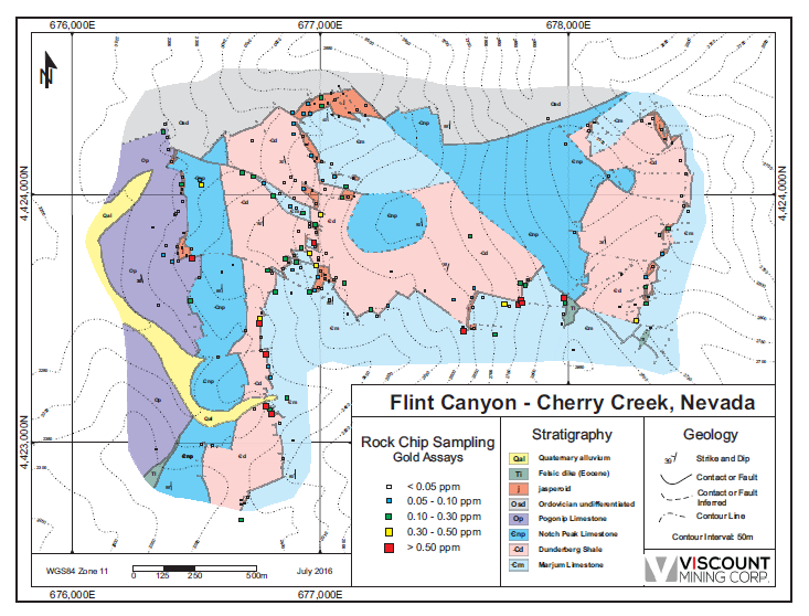
Rock Chip Sampling Program
The following points concerning geology and geochemistry in the mapped area are excerpts from the Summit “Activity Report for May-June 2016”.
The Flint Canyon Pogonip Limestone and Dunderberg Shale samples are highly anomalous in gold mineralization. Of the 1,250 rock samples collected in the Flint Canyon domain (includes west-southwest trending Black Metal Fault):
- Pogonip Limestone – Maximum gold grade of 0.345 g/t Au
- Pogonip Limestone – 22 samples > 0.02 g/t Au
- Dunderberg Shale – Maximum gold grade of 0.106 g/t Au
- Dunderberg Shale – 46 samples > 0.02 g/t Au
The rock chip sampling map shows that there is a very close relationship between anomalous gold assay values related to the areas at or near the jasperoid outcrops. There is also a close association of anomalous gold assays along the contact between the Dunderberg Shale and Marjum Limestone.
Work Planned and in Progress
Summit has committed to an additional 626 soil samples at Flint Canyon to extend the anomalous trends and fill in open priority target areas. Geologic mapping and rock chip sampling continues and work is being conducted south from Flint Canyon along the western flank of the mountain range.
Road contractor Legarza Exploration & Construction has started construction on the 7,046 ft. new access road at Flint Canyon and anticipates completion shortly.
Viscount anticipates the work on drill targeting at Flint Canyon will start later this summer when all of the laboratory data are received and map data formatted in the drill computer model. A minimum of 4,380m (14,366 feet) of reverse circulation (RC) drilling of 18 holes from 10 drill pads is expected to begin in early September 2016.
About Flint Canyon
The 2015 and 2016 mapping at Flint Canyon found the faulting to be more complex than previously indicated on the Adair 1961 geologic base map. Summit’s mapping program found that east-west orientated faults and fractures, which are important ore controlling structures at the Ticup and Star Mines, also occur in the area. The Flint Canyon area contains highly dissected fault blocks of the Dunderberg Shale with the underlying Marjum Limestone and overlying Notch Peak Limestone. The Pogonip Formation overlies the Notch Peak and both units are important host rocks for Carlin-type gold mineralization in east-central Nevada.
Jasperoid occurrences in Nevada are extremely significant in context to Carlin-type gold deposits and mineralized jasperoid outcrops are common throughout the Flint Canyon area. They occur principally along the base of the Dunderberg Shale, but other outcrops are found along the Pogonip-Notch Peak contact. Many major gold discoveries have been made based on the presence of outcropping, weakly mineralized jasperoid hosted in and along bedding contacts of carbonate rocks. At Flint Canyon, jasperoid is found in the same carbonate rocks that are prolific host rocks at nearby large gold deposits (Newmont Mining-Long Canyon, and Kinross Gold Corporation.-Bald Mountain deposits).
The jasperoid beds, interpreted as west dipping tabular features, occur along the base of the Dunderberg Shale and within the Pogonip group limestone. Summit’s geological team indicates that the Dunderberg Shale is generally recessive and is exposed mainly along the outcropping contacts with more competent rocks. The Dunderberg appears to be moderately altered throughout its distribution, and, at Flint Canyon, it experienced widespread and significant alteration by hydrothermal fluids. The underlying Marjum Limestone is usually competent and unaltered, while the overlying Pogonip exhibits variable alteration.
Mark Abrams, Viscount Technical Advisory Board, stated: “The recent soil sampling by Summit Mining at Flint Canyon has yielded gold and pathfinder element anomalies (Hg, As, Sb, Tl) similar in size and tenor to soil geochemical sampling results at other mines and advanced properties in the region, including Kinross Gold’s Bald Mountain mine; and Newmont Mining’s Long Canyon project, Agnico-Eagle’s West Pequop project and Pilot Gold’s Kinsley Mountain project. Mineralization identified by this work is hosted within and extending out from jasperoids formed at the Pogonip Limestone/Notch Peak Limestone contact, within the Dunderberg Shale, and within and extending out from jasperoids formed at the Dunderberg Shale/Marjum Limestone contact. Flint Canyon has continued to deliver exceptional results and we look forward to the upcoming drill program.”
QC and Analytical Procedures
The soil and rock chip analytical packages have been conducted by ALS Labs Limited, of Elko, Nevada. Soil samples were collected and analyzed for 52 elements, including gold, via ME‐MS41 and, for gold, Au-TL43, with over limit analyses for Au and Ag. Rock Chip samples were collected and analyzed for 48 elements via ME‐MS61, and, gold by AuAA‐23, with over limit analyses for Au, Ag, Pb, Zn and Cu.
Consult the ALS website for more information on the analytical packages being used on the Cherry Creek samples: http://www.alsglobal.com/Our-Services/Minerals/Geochemistry/Service-Schedule
Qualified Persons
The scientific and technical information contained in this news release has been reviewed and approved by Dallas W. Davis, PEng, FEC, an independent consulting geologist who is a “Qualified Person” as such term is defined under National Instrument 43-101 – Standards of Disclosure for Mineral Projects (“NI 43-101”).
The exploration and drill programs are being managed by David Tretbar, Summit Exploration’s Executive Vice President, Exploration and Mineral Resources, a Qualified Person as defined by NI 43-101. Mr. Tretbar is a registered Professional Geologist in Arizona (#48036) and a Certified Professional Geologist (CPG #11086) with the American Institute of Professional Geologists.
About Viscount Mining (TSX VENTURE: VML) (OTCQB: VLMGF)
Viscount Mining is an exploration company with a portfolio of gold and silver properties in the Western United States, including Cherry Creek in Nevada and Silver Cliff in Colorado. Cherry Creek is comprised of more than 9,000 acres, all 100% owned, and includes more than 20 past producing mines. Viscount has entered into an exploration earn-in agreement with Sumitomo Corporation covering the Cherry Creek property. Sumitomo can earn in up to a 75% interest in the property by producing a feasibility study and by spending in addition a minimum of US$10,000,000 in exploration and development expenses by the eighth anniversary of the earn-in agreement. Silver Cliff in Colorado is comprised of 96 lode claims, covering much of the historical past-producing mineral districts of Silver Cliff and Rosita Hills.
For additional information regarding the above noted property and other corporate information, please visit the Company’s website at www.viscountmining.com
About Sumitomo Corporation
Sumitomo Corporation is one of the largest integrated trading and investment companies in Japan. Sumitomo Corporation, a Fortune 500 company, conducts commodity transactions in all industries utilizing worldwide networks, provides related customers with various financing, serves as an organizer and a coordinator for various projects, and invests in businesses from the information industry to the retailing industry. Summit Mining Exploration, Inc. is a wholly-owned subsidiary of Sumitomo Corporation and is headquartered in Colorado, USA. For more information about Sumitomo Corporation, visit www.sumitomocorp.co.jp
ON BEHALF OF THE BOARD OF DIRECTORS
“Jim MacKenzie”
President, CEO and Director
For further information, please contact:
Viscount Investor Relations
Phone: 604-960-0535
Email: info@viscountmining.com
Neither TSX Venture Exchange nor its Regulation Services Provider (as that term is defined in the policies of the TSX Venture Exchange) accepts responsibility for the adequacy or accuracy of this release.
Forward-Looking Statements
This news release contains certain statements that may be deemed “forward-looking” statements. Forward looking statements are statements that are not historical facts and are generally, but not always, identified by the words “expects”, “plans”, “anticipates”, “believes”, “intends”, “estimates”, “projects”, “potential” and similar expressions, or that events or conditions “will”, “would”, “may”, “could” or “should” occur. Although Viscount Mining Corp. believes the expectations expressed in such forward-looking statements are based on reasonable assumptions, such statements are not guarantees of future performance and actual results may differ materially from those in forward looking statements. Forward looking statements are based on the beliefs, estimates and opinions of Viscount Mining Corp. management on the date the statements are made. Except as required by law, Viscount Mining Corp. undertakes no obligation to update these forward-looking statements in the event that management’s beliefs, estimates or opinions, or other factors, should change.
Stay In Touch